Zenmuse L2 integrates frame LiDAR, a self-developed high-accuracy IMU system, and a 4/3 CMOS RGB mapping camera, providing DJI flight platforms with more precise, efficient, and reliable geospatial data acquisition. When used with DJI Terra, it delivers a turnkey solution for 3D data collection and high-accuracy post-processing.
Integrated LiDAR Solution
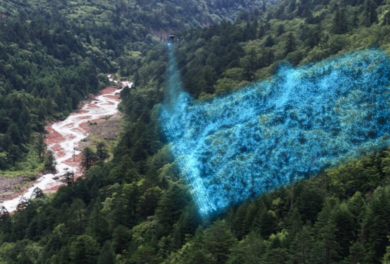
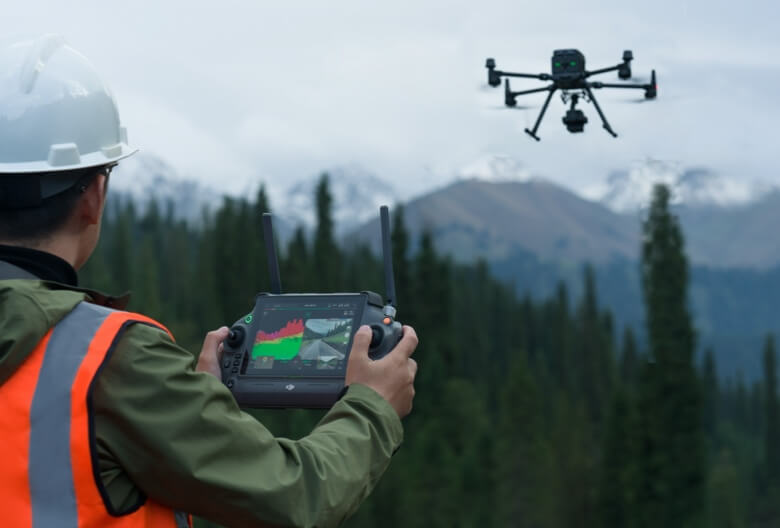
Supported by its powerful hardware, L2 can allow for a precise scan of complex subjects within an extended range and faster point cloud acquisition. During operations, users can preview, playback, and process point cloud models on-site, with Task Quality Reports generated by DJI Terra, offering a simple, one-stop solution to improve overall efficiency. This enables users to achieve high-precision point cloud results with one-stop post-processing.
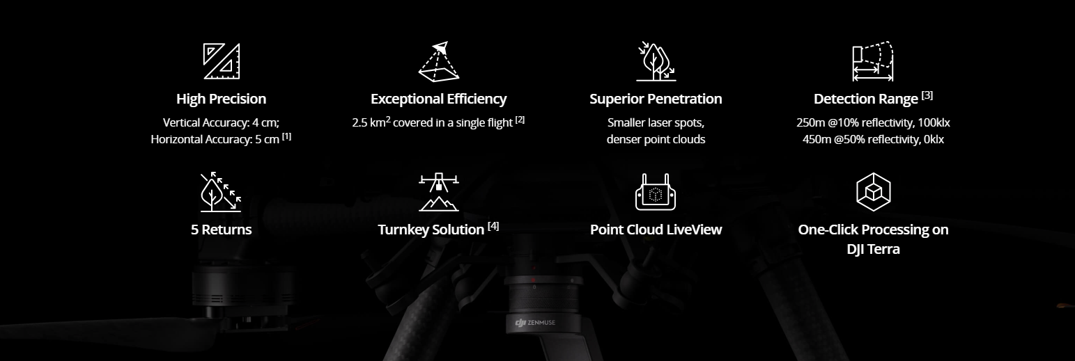
High-Level Precision
By combining GNSS and a high-accuracy self-developed IMU, this solution achieves 4cm vertical accuracy and 5cm horizontal accuracy.
Exceptional Efficiency
It’s ready for work as soon as it’s powered on and can collect both geospatial and RGB data from a 2.5km2 area in a single flight.
Intuitive Operation
In conjunction with Matrice 350 RTK and DJI Terra, L2 offers a turnkey solution that is simple to use, lowering the operational threshold.
Frame-Based LiDAR
30% Detection Range Increase
L2 can detect from 250 meters at 10% reflectivity and 100 klx, [3] and up to 450 meters at 50% reflectivity and 0 klx. [3] The typical operational altitude now extends up to 120 meters, notably enhancing operational safety and efficiency.
Smaller Laser Spots, Denser Point Clouds
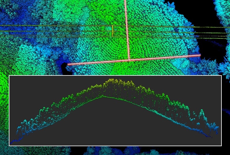
With a reduced spot size of 4×12 cm @100m, only a fifth of that of L1, L2 not only detects smaller objects with more details, but can also penetrate denser vegetation, generating more accurate digital elevation models (DEM).
Effective Point Cloud Rate: 240,000 pts/s
In both single and multiple return modes, L2 can reach a max point cloud emission rate of 240,000 points per second, allowing the acquisition of more point cloud data in a given time frame.
Supports 5 Returns
In densely vegetated areas, L2 can capture more ground points beneath the foliage.
General
Product Name
Zenmuse L2
Dimensions
155×128×176 mm (L×W×H)
Weight
905±5 g
Power
28 W (typical)
58 W (max.)
58 W (max.)
IP Rating
IP54
Supported Aircraft
Matrice 300 RTK (requires DJI RC Plus)
Matrice 350 RTK
Matrice 350 RTK
Storage Temperature
-20° to 60° C (-4° to 140° F)
General Operating Temperature
-20° to 50° C (-4° to 122° F)
System Performance
Detection Range
450m @50% reflectivity, 0 klx
250m @10% reflectivity, 100 klx
Typical data. Measured using a flat subject with a size larger than the laser beam diameter, perpendicular angle of incidence, and an atmospheric visibility of 23 km. In low-light environments, the laser beams can achieve the optimal detection range. If a laser beam hits more than one subject, the total laser transmitter power is split, and the achievable range is reduced. The maximum detection range is 500 m.
Point Cloud Rate
Single return: max. 240,000 pts/s
Multiple returns: max. 1,200,000 pts/s
Multiple returns: max. 1,200,000 pts/s
System Accuracy
Horizontal: 5 cm @ 150 m
Vertical: 4 cm @ 150 m
Measured under the following conditions in a DJI laboratory environment: Zenmuse L2 mounted on a Matrice 350 RTK and powered up. Using DJI Pilot 2’s Area Route to plan the flight route (with Calibrate IMU enabled). Using repetitive scanning with the RTK in the FIX status. The relative altitude was set to 150 m, flight speed to 15 m/s, gimbal pitch to -90°, and each straight segment of the flight route was less than 1500 m. The field contained objects with obvious angular features, and used exposed hard ground check points that conformed to the diffuse reflection model. DJI Terra was used for post-processing with Optimize Point Cloud Accuracy enabled. Under the same conditions with Optimize Point Cloud Accuracy not enabled, the vertical accuracy is 4 cm and the horizontal accuracy is 8 cm.
Real-Time Point Cloud Coloring Coding
Reflectivity, Height, Distance, RGB
LiDAR
Ranging Accuracy (RMS 1σ)
2 cm @ 150 m
Measured in an environment of 25° C (77° F) with a subject of 80% reflectivity at a distance of 150 m. The actual environment may differ from the testing environment. The figure listed is for reference only.
Maximum Returns Supported
5
Scanning Modes
Non-repetitive scanning pattern, Repetitive scanning pattern
FOV
Repetitive scanning pattern: Horizontal 70°, Vertical 3°
Non-repetitive scanning pattern: Horizontal 70°, Vertical 75°
Non-repetitive scanning pattern: Horizontal 70°, Vertical 75°
Minimum Detection Range
3 m
Laser Beam Divergence
Horizontal 0.2 mrad, Vertical 0.6 mrad
Measured at full width at half maximum (FWHM) conditions. 0.6 mrad signifies that for every 100m increase in distance, the diameter of the laser beam expands by 6 cm.
Laser Wavelength
905 nm
Laser Spot Size
Horizontal 4 cm, vertical 12 cm @ 100 m (FWHM)
Laser Pulse Emission Frequency
240 kHz
Laser Safety
Class 1 (IEC 60825-1:2014)
Accessible Emission Limit (AEL)
233.59 nJ
Reference Aperture
Effective Aperture: 23.85 mm (equivalent to circular)
Max Laser Pulse Emission Power Within 5 Nanoseconds
46.718 W
Inertial Navigation System
IMU Update Frequency
200 Hz
Accelerometer Range
±6 g
Angular Velocity Meter Range
±300 dps
Yaw Accuracy (RMS 1σ)
Real-time: 0.2°, Post-processing: 0.05°
Measured under the following conditions in a DJI laboratory environment: Zenmuse L2 mounted on a Matrice 350 RTK and powered up. Using DJI Pilot 2’s Area Route to plan the flight route (with Calibrate IMU enabled). RTK in the FIX status. The relative altitude was set to 150 m, flight speed to 15 m/s, gimbal pitch to -90°, and each straight segment of the flight route was less than 1500 m.
Pitch/Roll Accuracy (RMS 1σ)
Real-time: 0.05°, Post-processing: 0.025°
Measured under the following conditions in a DJI laboratory environment: Zenmuse L2 mounted on a Matrice 350 RTK and powered up. Using DJI Pilot 2’s Area Route to plan the flight route (with Calibrate IMU enabled). RTK in the FIX status. The relative altitude was set to 150 m, flight speed to 15 m/s, gimbal pitch to -90°, and each straight segment of the flight route was less than 1500 m.
Horizontal Positioning Accuracy
RTK FIX: 1 cm + 1 ppm
Vertical Positioning Accuracy
RTK FIX: 1.5 cm + 1 ppm
RGB Mapping Camera
Sensor
4/3 CMOS, Effective Pixels: 20 MP
Lens
FOV: 84°
Format Equivalent: 24 mm
Aperture: f/2.8-f/11
Focus Points: 1 m to ∞ (with autofocus)
Format Equivalent: 24 mm
Aperture: f/2.8-f/11
Focus Points: 1 m to ∞ (with autofocus)
Shutter Speed
Mechanical Shutter: 2-1/2000 s
Electronic Shutter: 2-1/8000 s
Electronic Shutter: 2-1/8000 s
Shutter Count
200000
Photo Size
5280×3956 (4:3)
Still Photography Modes
Single shot: 20 MP
Timed: 20 MP
JPEG Timed Interval: 0.7/1/2/3/5/7/10/15/20/30/60 s
RAW/JPEG + RAW Timed Interval: 2/3/5/7/10/15/20/30/60 s
Timed: 20 MP
JPEG Timed Interval: 0.7/1/2/3/5/7/10/15/20/30/60 s
RAW/JPEG + RAW Timed Interval: 2/3/5/7/10/15/20/30/60 s
Video Codec and Resolution
H.264, H.265
4K: 3840×2160 @30fps
FHD: 1920×1080 @30fps
4K: 3840×2160 @30fps
FHD: 1920×1080 @30fps
ISO
Video: 100-6400
Photo: 100-6400
Photo: 100-6400
Video Bitrate
4K: 85Mbps
FHD: 30 Mbps
FHD: 30 Mbps
Supported File System
exFAT
Photo Format
JPEG/DNG (RAW)
Video Format
MP4 (MPEG-4 AVC/H.264 or HEVC/H.265)
Gimbal
Stabilization System
3-axis (tilt, roll, pan)
Angular Vibration Range
0.01°
Mounting
Detachable DJI SKYPORT
Mechanical Range
Tilt: -143° to +43°
Pan: ±105°
* Structural limit, not controllable range.
Controllable Range
Tilt: -120° to +30°
Pan: ±90°
Pan: ±90°
Operation Mode
Follow/Free/Re-center
Data Storage
Raw Data Storage
Photo/IMU/Point cloud/GNSS/Calibration files
Point Cloud Data Storage
Real-time modeling data storage
Supported microSD Cards
microSD: Sequential writing speed 50 MB/s or above and UHS-I Speed Grade 3 rating or above; Max capacity: 256 GB. Use the recommended microSD cards.
Recommended microSD Cards
Lexar 1066x 64GB U3 A2 V30 microSDXC
Lexar 1066x 128GB U3 A2 V30 microSDXC
Kingston Canvas Go! Plus 128GB U3 A2 V30 microSDXC
Lexar 1066x 256GB U3 A2 V30 microSDXC
Lexar 1066x 128GB U3 A2 V30 microSDXC
Kingston Canvas Go! Plus 128GB U3 A2 V30 microSDXC
Lexar 1066x 256GB U3 A2 V30 microSDXC
Post-Processing
Supported Software
DJI Terra
Data Format
DJI Terra supports exporting point cloud models in the following formats:
PNTS/LAS/PLY/PCD/S3MB
PNTS/LAS/PLY/PCD/S3MB
Contact Us
If you wish to purchase products, please leave your contact information below. We will be in contact with you shortly.